Showing posts with label warm. Show all posts

Arctic Sea Ice Steep Decline Continues


Steep decline of the Arctic sea ice continues. The yellow line on the image below follows 2014 sea ice area up to June 5 and shows that sea ice area now is close to a record low for the time of the year.

[ click on image to enlarge ]
The Naval Research Laboratory image below compares sea ice concentration on May 14, 2014 (left) with the sea ice concentration forecast for June 15, 2014 (run on June 7, 2014, on the right).


Above image shows falling sea ice concentration, with low sea ice concentration extending to the center of the Arctic Ocean.

Low sea ice concentration at the center of the Arctic Ocean is an ominous sign; at last year's minimum, very little sea ice was left close to the North Pole, as discussed in an earlier post.

On the right is an image of the University of Bremen showing sea ice concentration on June 8, 2014 (click on the images to enlarge them).

Arctic sea ice already is very thin, as discussed in recent posts. The image below shows that the sea ice volume trend down to zero was confirmed for the months April and May 2014.

[ image by Andy Lee Robinson based on PIOMAS data, click on image to enlarge ]
The lowest sea ice volume for 2014 is expected to be reached in September, and - given the shape the ice is in now - will likely be one of the lowest minima on record. In fact, there is a chance that there will be no ice left whatsoever later this year. As illustrated by the image by Wipneus below, an exponential curve based on annual minima from 1979 points at zero ice volume end 2016, with the lower limit of the 95% confidence interval pointing at zero ice end of 2014.
As the sea ice disappears, a lot more heat will be absorbed by the Arctic Ocean. Sea ice reflects 50% to 70% of the incoming energy, describes NSIDC.org, but thick sea ice covered with snow reflects as much as 90% of the incoming solar radiation. Melting of snow creates melt ponds on the ice and because shallow melt ponds have an albedo of approximately 0.2 to 0.4, the surface albedo drops to about 0.75. As melt ponds grow and deepen, the surface albedo can drop to 0.15. The ocean reflects only 6% of the incoming solar radiation and absorbs the rest. Snow and ice decline comes with a further feedback in that all the energy that during the melt went into transforming ice into water will - in the absence of ice - now be absorbed by the ocean as well.

Accelerated Warming in the Arctic

[ from the post Near-Term Human Extinction ]
Such feedbacks are causing warming to accelerate in the Arctic Ocean, as depicted in above image and described in the earlier post Feedbacks in the Arctic. Much of the Arctic Ocean is very shallow and the seafloor is thus vulnerable to warming. The Gulf Stream can be expected to keep carrying warmer water into the Arctic Ocean, so the situation is dire, while extreme weather events such as heatwaves and cyclones can make the situation even worse.

The NOAA image below shows huge sea surface temperature anomalies all over the Northern Hemisphere on June 8, 2014.

[ click on image to enlarge ]
Large areas with sea surface temperature anomalies up to 8°C and higher show up in and around the Arctic Ocean, as further illustrated by the image below.

[ click on image to enlarge ]
The image below shows high sea surface temperature anomalies from February 21, 2014, up to June 9, 2014, on the Northern Hemisphere (red bars), next to global average anomalies (orange/shaded bars).


The global sea surface temperature anomaly is worrying (a 1.25°C anomaly was reached on May 22, 2014). See the NOAA website to compare this with earlier months. Note that on specific spots the anomaly is much higher, as illustrated by the images further above.

Warm surface waters in the Arctic sea ice spell bad news, given that the sea ice is already at or close to record lows, in terms of area and volume.

And as ocean heat threatens to melt the sea ice from beneath, the sun is now strongly warming up the ice from above. Insolation in the Arctic is at its highest at this time of year, as Earth reaches its maximum axial tilt toward the sun of 23° 26'. In fact, insolation during the months June and July is higher in the Arctic than anywhere else on Earth, as discussed at this earlier post.

The diminishing temperature difference between the equator and the North Pole reduces the speed at which the Jet Stream circumnavigates Earth and it makes the Jet Stream become wavier, increasing opportunities for cold air to escape from the Arctic and for warm air to move in. More extreme weather increases the chance of intense and prolonged heatwaves and fierce cyclones, storms and winds to hit the Arctic Ocean.

Making things even worsen, there is the prospect of an El Niño event, projected to occur later this year. According to NOAA (June 5, 2014), the chance of El Niño is 70% during the Northern Hemisphere summer and reaches 80% during the fall and winter. El Niño odds are even higher than this, according to this post at the Wunderground blog.


Methane

Temperature rises of the water close to the seafloor of the Arctic Ocean are very dangerous, as heat can penetrate sediments and cause hydrate destabilization. Huge amounts of methane are held in sediments at the seafloor, in the form of free gas and hydrates. In shallow waters, methane released from the seafloor can more easily enter the atmosphere without getting broken down by microbes in the water.

Methane levels are already very high. On June 6, 2014, mean global methane reached levels as high as 1809 ppb, with peaks as high as 2516 ppb.

Methane release from the seafloor of the Arctic Ocean will warm up the Arctic even further, triggering even more methane releases, heatwaves, wildfires and further feedbacks, in a spiral of runaway warming, threatening to cause starvation, destruction and extintion at massive scale across the globe.


Earthquakes

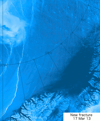
Earthquakes are a further worry. A huge amount of melting takes place in Greenland, as described in the post Ten Cubic Kilometers of Ice Lost From Jakobshavn Glacier in Less than One Month. As the ice disappears, a large weight is lefted from Greenland, causing the Earth's crust there to be lifted in a phenomenon referred to as isostatic rebound. This can cause earthquakes to occur on the seafloor of the waters around Greenland, as illustrated by the image below.

[ click on image to enlarge ]

As the image below shows, the faultline alongside Greenland crosses the Arctic Ocean and extends into the Laptev Sea and Siberia, an area recently hit by two large earthquakes.

[ click on image to enlarge ]
Earthquakes in this region are very worrying. Earthquakes can trigger further earthquakes, especially at locations closeby on the same faultline. Earthquakes and subsequent shockwaves and landslides can further contribute to destabilization of methane hydrates contained in sediments under the seafloor of the Arctic Ocean.

In conclusion, the situation is dire and calls for comprehensive and effective action, as discussed at the climate plan blog.


Related

- M4.4 Earthquake hits Arctic Ocean north of Greenland
http://arctic-news.blogspot.com/2014/04/m45-earthquake-hits-arctic-ocean.html

- M4.5 Earthquake hits Arctic Ocean
http://arctic-news.blogspot.com/2014/04/m45-earthquake-hits-arctic-ocean.html

- Earthquakes in the Arctic Ocean
http://arctic-news.blogspot.com/2014/04/earthquakes-in-the-arctic-ocean.html

- Methane, Faults and Sea Ice
http://arctic-news.blogspot.com/2013/11/methane-faults-and-sea-ice.html

- Norwegian Sea hit by 4.6M Earthquake
http://arctic-news.blogspot.com/2013/11/norwegian-sea-hit-by-46m-earthquake.html

- Greenland Sea hit by M5.3 Earthquake
http://arctic-news.blogspot.com/2013/10/greenland-sea-hit-by-m53-earthquake.html

- Earthquake hits waters off Japan
http://arctic-news.blogspot.com/2013/10/earthquake-hits-waters-off-japan.html

- Earthquake hits Laptev Sea
http://arctic-news.blogspot.com/2013/09/earthquake-hits-laptev-sea.html

- Methane Release caused by Earthquakes
http://arctic-news.blogspot.com/2013/09/methane-release-caused-by-earthquakes.html

- Earthquake M6.7 hits Sea of Okhotsk
http://methane-hydrates.blogspot.com/2013/10/earthquake-m67-hits-sea-of-okhotsk.html

- Sea of Okhotsk
http://methane-hydrates.blogspot.com/2013/06/sea-of-okhotsk.html

- Seismic activity
http://arctic-news.blogspot.com/p/seismic-activity.html

- Climate Plan
http://climateplan.blogspot.com

Causes of high methane levels over Arctic Ocean

Methane levels in the atmosphere over the Arctic Ocean are very high, as illustrated by the image below, by Leonid Yurganov, showing IASI methane readings for October 11-20, 2013.


Previous posts have discussed these high levels of methane, pointing at links between high methane levels over Arctic Ocean and earthquakes and volcanic activity.

Malcolm Light points at another factor that is contributing to the high methane levels observed over the Arctic Ocean in October 2013.

Malcolm says: The massive methane release in the Arctic this October is partly because the Gulf Stream waters got massive heating in the Atlantic off the North American coast in July. It takes the Gulf Stream currents almost 4 months to reach the emission sites along the southern side and end of the Eurasian Basin. This combined with the earthquake activity along the Gakkel Ridge and deep pyroclastic eruptions is escalating the rate of methane release by destabilizing the submarine Arctic methane hydrates at increasing rates.

The NOAA image below shows temperature anomalies for July 2013. NOAA adds that in July 2013 many regions were much warmer than average, with part of the northeastern Atlantic off the coast of North America observing record warmth.


The image below shows how water traveling along the Gulf Stream ends up in the Arctic Ocean. Water in the Gulf Stream travels at 4 miles per hour, but slows down to less than 1 mile per hour in the North-Atlantic Current. This means that water warmed up off Florida in July will start reaching waters beyond Svalbard in October.


The image below, from Malcolm Light's September 2012 post Further Confirmation of a Probable Arctic Sea Ice Loss by Late 2015, shows how warm water flows into the Arctic Ocean and warms up methane hydrates and free gas held in sediments under the Arctic Ocean.
 The image below shows the methane readings over the past few days on the Northern Hemisphere.


Huge patches of warm air over the Arctic

Over the past month or so, huge patches with temperature anomalies of over 20 degrees Celsius have been forming over the Arctic.

The three images below show such patches stretch out from Svalbard to Novaya Zemlya (top), north of Eastern Siberia (middle) and over West Greenland and Baffin Bay (bottom).


How these patches with warm air developed is further illustrated by the animation below, which goes from February 12, 2013, to March 18, 2013.


This is a 2.3 MB file that may take some time to fully load. 

Paul Beckwith, regular contributor to the Arctic-news blog, comments:
Paul Beckwith,
B.Eng, M.Sc. (Physics),
Ph.D. student (Climatology)
and Part-time Professor,
University of Ottawa
 

"The problem with this type of pattern is that there is a tendency for what is termed the AD (Arctic Dipole) consisting of exceptionally high pressures over Northern Canada to Greenland. When the air leaves this region heading for the low pressure regions (winds) it curves to the right (due to Coriolis force) and is thus driven from the Bering Strait region to the North Pole and then out Fram Strait, this conduit is like flushing the toilet on the ice. Warm water is pulled to the cold North Pole and the ice is driven out the Fram Strait into the warm Atlantic where it is melted."

"But the really big problem is that this high pressure area over Northern Canada is a ridge (blocking) that stays pretty stationary over the summers and is directly causing the heat waves and drought in the western US (2003, 2011, 2012). Another really big problem is that the part of the ridge over Greenland (or large GBI = Greenland Blocking Index); as discussed by Overland, Francis, et. al. in 2012 causes excessive melt in Greenland (as we saw in July, 2012 when 97% of Greenland was melting on the surface instead of the usual 40%). This is sending the Greenland albedo into a steep drop, causing even more heat absorption and melting."

To illustrate this further, Paul adds the animation below, from weather.unisys.com.

This animation is a 1 MB file that may take some time to fully load
Paul adds: "The Greenland high could reach 1070 mb in next few days; that will bring huge temperatures! By comparison, the world record highest was 1085 in Mongolia in December 19, 2001".

The 1070 mb high over Greenland is further illustrated by the image below, from weather.unisys.com.


Indeed, as the jet stream slows down and becomes more wavier, such patches of warm air can be expected to extend more regularly into the Arctic. The result can be a huge melt of Arctic sea ice, as well as a huge melt of snow cover in Greenland, which also dramatically lowers albedo, as occurred in 2012 and as discussed in the earlier post Greenland is melting at incredible rate.

This spells bad news for the Arctic sea ice, which may well disappear altogether this summer.

Paul further adds: "For the record; I do not think that any sea ice will survive this summer. An event unprecedented in human history is today, this very moment, transpiring in the Arctic Ocean. The cracks in the sea ice that I reported on my Sierra Club Canada blog and elsewhere over the last several days have spread and at this moment the entire sea ice sheet (or about 99% of it) covering the Arctic Ocean is on the move. Clockwise. The ice is thin, and slushy, and breaking apart."

"This is abrupt climate change in real-time. Humans have benefitted greatly from a stable climate for the last 11,000 years or roughly 400 generations. Not any more. We now face an angry climate. One that we have poked in the eye with our fossil fuel stick and awakened. And now we must deal with the consequences. We must set aside our differences and prepare for what we can no longer avoid. And that is massive disruption to our civilizations."

The animation below, from genomewiki.ucsc.edu shows cracks in the sea ice with the Wikipedia image underneath showing the location.


Related posts

- Polar jet stream appears hugely deformed
- Hurricane Sandy moving inland